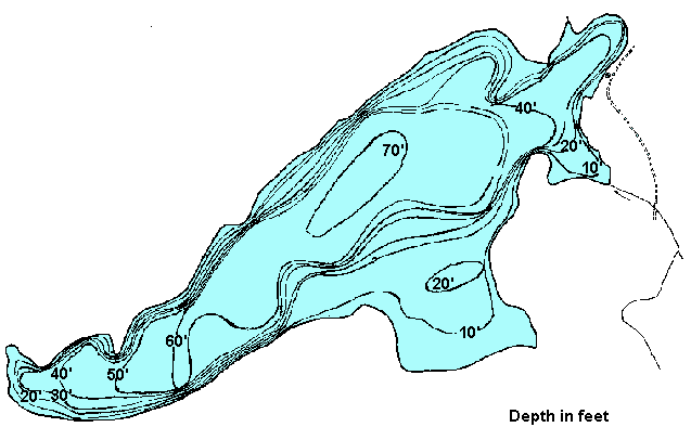
BC's On-Line  Hotel  Reservation System
Contents   Cariboo Chilcotin Coast

Google

Cariboo Chilcotin Coast
Lodging & Services
Recreation
Cities & Towns
Lakes

Travel Info
Points of Interest
Provincial Parks
Trails

Visit BC
Cariboo Chilcotin Coast
Northern BC
Rockies Kootenays
Thompson Okanagan
Vancouver & Coast
Vancouver Island

City Guides
BC Communities
BC Vacations
Fishing Vacations
Western Vacations
Eco-Adventures
Storm Watching
Ski Vacations

Golf Vacations
RV Vacations
Houseboat Vacations
Outdoor Adventures
Camping Expeditions
Guides & Outfitters
Guided Tours
Charters
Attractions
Events
Lodging
Search Lodgings
Hotels, Motels & B&Bs
Suites, Rentals & Condos
Wilderness Resorts
Saltwater Resorts
Guest Ranches
Health Spas, Hot Springs
Golf & Ski Resorts

Campgrounds & RV Parks
Add a Listing
Recreation
Search by Activity
Attractions

ATV
Boating
Camping
Canoe & Kayak
Dog Sledding
Fishing
Golf
Horseback Riding
Guided Tours
Health/Spas
Cat & Heli-Skiing
Hiking
House Boating
Mtn. Biking
Mtn. Climbing
Hot Springs
River Rafting

Scuba Diving
Skiing
Snowmobiling
Whale Watching
Fish BC
Saltwater Fishing
Lake Fishing
River Fishing
Fishing Vacations
Fishing Suppliers
BC Game Fish
Trophy Destinations
BC Fly Patterns
Entomology
Tips & Techniques
Travel Routes
Circle Tours
Maps
Points of Interest
Travel Logs
Brochure Rack
Browse
Trip Planner
Plan Your Vacation
Tourist Info

Special Events
 Road Reports
 Weather Reports
 Mileage Calculator
Coastal Ferry Info
Vancouver Airport
Transportation
BC Quick Facts
Customs
Currency
Taxes
Medical
Metric System
Motor Vehicles
Time Zones
Area Codes

Outdoors
Animals
Birds
Fish
Wildflowers
Trees
Survival
Parks
Trails

Wines of BC
BC Wines
Wineries
Wine Tours


www.bcadventure.com
Palmer Lake
Click on the lake icon at the right to see full bathymetric map.
Click on the moose on the left for complete BC travel information.


Location:
At Williams Lake turn west onto Highway 20. About 21 km (13 mi) west of Riske Creek turn north off Hwy 20 onto the Palmer Lake Forest Access Road. The lake is 71 km (44 mi) after you turn off Hwy 20. The last 6.5 km (4 mi) is very steep and rough. 2WD can make it, but if it rains you will need a 4x4.

Size 210 ha. (518 ac.) Shoal 69.20 ha. (170 ac.)
Mean Depth 11.4 m.(37.3 ft.) Max. Depth 23.16 m.(76 ft.)
Game Fish Rainbow Trout Fish Stocked Rainbow Trout
Angler Usage Moderate to Heavy Elevation 1,160 m.(3,804 ft.)
Ice Over November - May T.D.S. 233 mg/L

Resorts & Campsites: Palmer has a well developed BCFS campsite with boat launching. No trailers because of steep access road.

Fishing Report: A very consistant producer of 3 lb rainbows throughout the season. Much larger trout are not uncommon. Trolling is preferred. Palmer has a large population of scuds and other invertebrates. Fly fishing can be excellent.
Be sure to visit Fishbc.com for angling information!

Viewscape: A beautiful clear lake, Palmer lies in gently rolling terrain, mostly forested in Lodgepole Pine and White Spruce, with a few scrub birch near shore.

Shoreline: Peaty brown, gravelly, forest soil surrounds most of the lake with some nice gravel beaches.

Nearby Lakes

MacKill Lake - Continue on the Palmer Lake Forest Access Road about 6 km (3.72 mi) past the final access to Palmer Lake. You will reach a well marked parking area. MacKill is found at the end of a 1 kilometre (0.62 mi) walk-in trail. This is a rainbow stocked lake. A great children's lake providing lots of smaller rainbows on flies or spinners. Bring tents and float tubes.

Note: Always check your current BC Fishing regulations before you start fishing a new lake.


Global Marketing Specialists

Advertise With Us

Promote your business to over 5.5 million BC visitors per year.
A
dvertise on the BC Adventure Network, British Columbia's largest and most visited tourism Web site . . . more info.


© 1995 - 2008 Interactive Broadcasting Corporation