Drainage
Overview
Physiography | Geology
| Tectonics | Soils
| Drainage | Vegetation
 British
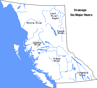
Columbia is drained by six major rivers - Fraser, Columbia, Peace, Skeena,
Stikine and Liard. In addition, a large number of short rivers drain west
to the Pacific Ocean from the Coast Mountains, and a few others drain Vancouver
Island and the Queen Charlotte Islands.
British
Columbia is drained by six major rivers - Fraser, Columbia, Peace, Skeena,
Stikine and Liard. In addition, a large number of short rivers drain west
to the Pacific Ocean from the Coast Mountains, and a few others drain Vancouver
Island and the Queen Charlotte Islands.
The Fraser River Drainage Basin has an area of roughly
233,000 square kilometres. At the mouth, its estimated mean annual discharge
is about 3800 cubic metres per second. To date only two of the Fraser's
tributaries have been dammed - the Bridge River and the Nechako River.
In the case of the Nechako River, its headwaters in Tweedsmuir
Park have been diverted to the Pacific slope through the Kemano tunnel.
The most devastating floods on the Fraser River took place
in 1894 and in 1948. In addition, on February 23, 1914, a rockslide cut
the flow of the Fraser River to a trickle at Hell's Gate. The slide was
largely the result of work to build the Canadian Northern Railway.
The Columbia River Basin, just under half the size of
the Fraser Basin at 102,000 square kilometres, has a discharge of 2193
cubic metres per second. The Columbia's main tributaries are the Kootenay,
Similkameen and Okanagan Rivers, each of which has some portion of its
route in the United States.
Perhaps the most significant event to affect this river
has been the Columbia Valley Treaty signed in the 1960s. This treaty allowed
the construction of major dams on the Columbia River and its tributaries
on both sides of the border.
The Peace River Drainage Basin, with an area of 128,000
square kilometres and a discharge of 1560 cubic metres per second, is formed
by the conjunction of the Finlay and Parsnip Rivers. The flow of the Peace
River is considerably controlled now due to the construction of the W.
A. C. Bennett Dam.
The Liard River Basin is located in the province's far
north eastern corner, with an area of 144,000 square kilometres and a mean
annual discharge of about 1380 cubic metres per second. Partly because
of its distance from major urban centres, little is known or understood
about this river.
The Stikine River flows west into the Pacific Ocean and
drains an area of roughly 51,000 square kilometres and has an estimated
discharge of 1350 cubic metres per second. Surveys in the late 1960s indicated
this river held a number of potential hydro electric dam sites.
Just south of the Stikine is the Skeena River Drainage
Basin. With a drainage area of roughly 54,000 square kilometres and an
estimated discharge of 1730 cubic metres per second, it is the province's
second most important salmon river after the Fraser. One of the river's
unique qualities is the softness of its water. This is due to the fact
that creeks and rivers emptying into the Skeena are short; therefore, their
water has had little opportunity to pick up soluble minerals.
Any study of British Columbia's rivers quickly reveals
several issues for consideration. Foremost on this list is the lack of
data. There are few locations where river data have been gathered, and
the few that do exist offer a very short record of reliable information.
Equally important are the pressures on this renewable resource as population
grows, industry expands, wilderness access increases, and traditional land
uses are altered. Nevertheless, the resource remains a spectacular component
of the province's landscape.

 © 1996-
INTERACTIVE BROADCASTING CORPORATION
© 1996-
INTERACTIVE BROADCASTING CORPORATION