Despite the great diversity of British Columbia's physical
features, the distribution of soils, climate patterns, vegetation, and
terrain can be correlated to define the broader "look" to the landscape.
These are the Physiographic Regions, and they show a linear pattern that
runs roughly northwest - southeast. Within each belt are a number of sub-regions
that further help define the province.
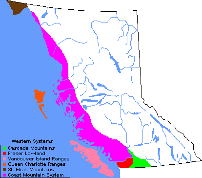
The Western System includes the mountains of Vancouver Island and the Queen Charlotte Islands, as well as the western-most reaches of the Coast Mountains and their adjacent islands. To the east of these Insular Mountains are the various ranges of the Coast Mountains. In the north this includes a small portion of the Mt. St. Elias range and in the south a small portion of the Cascades.
For the most part, the Western System is rugged. Flanking
the fjords are mountains that rise thousands of feet from the sea shore;
many of these mountain sides are near vertical. Extensive mountain glaciers
cover the higher elevations of the mainland ranges south of Bella
Coola and east of the Alaska panhandle. Long fjords and numerous island
chains make navigation dangerous and reliable communication difficult.
British Columbia's highest peak, Fairweather Mountain, is in this zone.
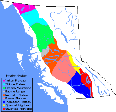
The Interior System is comprised of a series of plateaus and low mountain ranges. In the far north is the Yukon-Stikine Plateau, to the south of which are the Skeena Mountains. From these ranges south to the United States border is the great expanse of the Interior Plateau. This plateau has been further sub-divided into a series of plateaus and highlands.
Generally, this is a region of relatively low relief.
Large portions of the Fraser and Thompson Plateaus, for example, undulate
only a few hundred feet over wide areas. This terrain presents spectacular
scenery in two ways. First, from a few vantage points the gently rolling
plateau can be seen to stretch almost endlessly. Second, many of the region's
rivers have cut into the plateau leaving deep, rugged canyons.
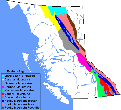
The Eastern System is a melange of mountain ranges that rise toward the east and culminate in the grandeur of the Rocky Mountains. Dividing the region in two is the Rocky Mountain Trench, a geological fault line.
In the south, the north-south trend of the mountain systems is easily defined by the Monashee, Selkirk and Purcell Ranges and by the long, narrow lakes that separate them. In the north, however, many river valleys run east or west across the Cassiar or Omineca Ranges.
Most visually striking and most widely popularized are
the Rocky Mountains that meet the Alberta border in the southern half of
the province. What makes them even more imposing is their contrast against
the depth of the Rocky Mountain Trench in the west and the prairie lands
to the east. The highest peaks in the Rocky Mountains are located in the
southern half.
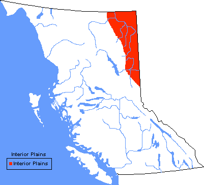
The Interior Plains dominates British Columbia's north east corner. Known as the Peace River District, this is an extension of the prairie lands that make up Alberta and much of southern Saskatchewan and Manitoba. It is a gently rolling landscape that decreases in elevation from west to east. Like the Interior Plateau of central British columbia, this is a region of subtle landform changes where many rivers have cut deeply into the surrounding lands.